


Trekarta - offline maps for outdoor activities
Andrey Novikov
คำอธิบายของTrekarta - offline maps for outdoor activities
Trekarta is designed for hiking, geocaching, off-roading, cycling, boating and all other outdoor activities. It uses offline maps so you do not need to have internet connection. You can easily import places and tracks from GPX and KML data formats or create places in application and share them to others. It lets you write the track of your journey, even in background, so you will never get lost and be able later see where you've been.
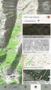
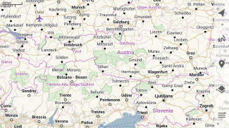
Offline maps
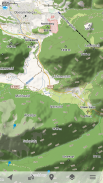
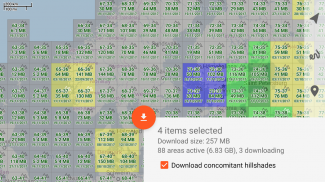
Trekarta uses OpenStreetMap based vector maps that are lightweight, offline and are constantly enhanced by contributors. Maps contain detailed topological data with elevation contours. Some map elements can be filtered out for cleaner look. Trekarta has built-in hillshades support. You can add custom maps in sqlite or mbtiles format to cover your area of interest. Custom maps will be shaded as well. Such maps can be created by yourself with SAS.Planet application from mostly any online source or converted with MapTiler and other applications from other map formats.
Hiking
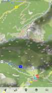
Special hiking activity mode emphasises paths and tracks on map. It visualizes path difficulty and visibility and displays hiking routes. It also displays special OSMC symbols that help you identify desired route.
Skiing and skating
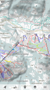
Skiing activity mode displays clean winter map with mostly all skiing activities: downhill, nordic, hiking and touring. As a bonus freestyle snow-boarding, skating and sleighing areas are displayed.
Off-road
Unpaved, dirt, winter and ice roads are specially visualized. 4wd only roads have specific marking. Fords are displayed on all roads, even primary.
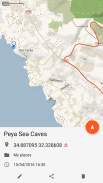
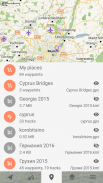
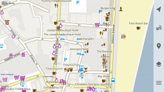
Places
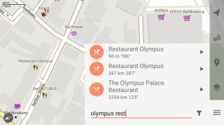
Places can be easily imported from GPX and KML files or can be created within application. You can navigate to places and share them with others.
Tracks
Trekarta is designed to record tracks of your journey. Simply press a button when you start and press it once more when you finish. You can quit the application if you do not need to look at the map, the track will be recorded in the background.
Plugins
Trekarta functionality can be extended by plugins. Currently the following plugins are available:
• Location sharing
• Dropbox sync
More info
More information can be found at:
https://andreynovikov.info/tag/trekarta.html
Questions can be asked at:
https://groups.google.com/d/forum/trekarta
Trekarta ได้รับการออกแบบมาสำหรับการปีนเขา, geocaching, off-roading, ปั่นจักรยาน, พายเรือและกิจกรรมกลางแจ้งอื่น ๆ มันใช้แผนที่ออฟไลน์ดังนั้นคุณไม่จำเป็นต้องเชื่อมต่ออินเทอร์เน็ต คุณสามารถนำเข้าสถานที่และแทร็กจากรูปแบบข้อมูล GPX และ KML หรือสร้างสถานที่ในแอปพลิเคชันและแบ่งปันให้ผู้อื่น มันช่วยให้คุณเขียนเส้นทางการเดินทางของคุณได้แม้ในพื้นหลังดังนั้นคุณจะไม่หลงทางและสามารถดูได้ว่าคุณอยู่ที่ไหนในภายหลัง
แผนที่ออฟไลน์
Trekarta ใช้แผนที่เวกเตอร์ที่ใช้ OpenStreetMap ซึ่งมีน้ำหนักเบาออฟไลน์และได้รับการปรับปรุงอย่างต่อเนื่องโดยผู้มีส่วนร่วม แผนที่มีข้อมูลทอพอโลยีอย่างละเอียดพร้อมรูปทรงระดับความสูง องค์ประกอบแผนที่บางอย่างสามารถกรองออกเพื่อให้ดูสะอาดตา Trekarta ได้รับการสนับสนุนบริเวณเชิงเขาในตัว คุณสามารถเพิ่มแผนที่ที่กำหนดเองในรูปแบบ sqlite หรือ mbtiles เพื่อครอบคลุมพื้นที่ที่คุณสนใจ แผนที่ที่กำหนดเองจะถูกแรเงาเช่นกัน แผนที่ดังกล่าวสามารถสร้างได้ด้วยตัวเองด้วยแอปพลิเคชัน SAS.Planet จากแหล่งออนไลน์ส่วนใหญ่หรือแปลงด้วย MapTiler และแอปพลิเคชันอื่น ๆ จากรูปแบบแผนที่อื่น ๆ
ธุดงค์
โหมดกิจกรรมเดินป่าพิเศษเน้นเส้นทางและแทร็กบนแผนที่ มันแสดงให้เห็นถึงความยากลำบากของเส้นทางและการมองเห็นและแสดงเส้นทางเดินป่า นอกจากนี้ยังแสดงสัญลักษณ์ OSMC พิเศษที่ช่วยให้คุณระบุเส้นทางที่ต้องการ
การเล่นสกีและเล่นสเก็ต
โหมดกิจกรรมการเล่นสกีแสดงแผนที่ฤดูหนาวที่สะอาดโดยส่วนใหญ่จะเป็นกิจกรรมการเล่นสกีทั้งหมด: ลงเขา, นอร์ดิก, เดินเขาและท่องเที่ยว ในฐานะที่เป็นสโนว์บอร์ดโบนัสฟรีสไตล์พื้นที่เล่นสเก็ตและเลื่อนจะปรากฏขึ้น
ปิดถนน
ถนนลาดยางดินฤดูหนาวและถนนน้ำแข็งถูกมองเห็นเป็นพิเศษ ถนน 4wd เท่านั้นที่มีเครื่องหมายเฉพาะ ฟอร์ดจะแสดงบนถนนทุกสายรวมถึงสายหลัก
สถานที่
สถานที่สามารถนำเข้าได้อย่างง่ายดายจากไฟล์ GPX และ KML หรือสามารถสร้างขึ้นภายในแอปพลิเคชัน คุณสามารถนำทางไปยังสถานที่ต่างๆและแบ่งปันกับผู้อื่น
เพลง
Trekarta ถูกออกแบบมาเพื่อบันทึกเส้นทางการเดินทางของคุณ เพียงแค่กดปุ่มเมื่อคุณเริ่มและกดอีกครั้งเมื่อคุณเสร็จสิ้น คุณสามารถออกจากแอปพลิเคชั่นหากคุณไม่จำเป็นต้องดูแผนที่แทร็กจะถูกบันทึกในพื้นหลัง
ปลั๊กอิน
ฟังก์ชั่น Trekarta สามารถขยายได้โดยปลั๊กอิน ปัจจุบันมีปลั๊กอินดังต่อไปนี้:
•การแชร์ตำแหน่ง
•การซิงค์ Dropbox
ข้อมูลเพิ่มเติม
ข้อมูลเพิ่มเติมสามารถดูได้ที่:
https://andreynovikov.info/tag/trekarta.html
คำถามสามารถถามได้ที่:
https://groups.google.com/d/forum/trekarta
Trekarta - offline maps for outdoor activities--เวอร์ชั่น2023.11
(30-11-2023)
Trekarta - offline maps for outdoor activities - ข้อมูล APK
เวอร์ชั่น APK: 2023.11แพ็คเกจ: mobi.maptrekเวอร์ชั่นล่าสุดของTrekarta - offline maps for outdoor activities


แอปในประเภทเดียวกัน


